The Golfe of Morbihan

Situated in the south-eastern part of Brittany, the Gulf of Morbihan belongs to the very select club of the world’s most beautiful bays, alongside San Francisco Bay and Halong Bay. (The fact that this club was created by 3 people from Vannes in no way calls into question the objectivity of our Breton jury when it came to judging the beauty of their own region).
Présentation
The Gulf of Morbihan is 20 km long from east to west and 15 km wide from north to south. It opens onto the Bay of Quiberon, the western part of the Mor Braz (the great sea, the ocean) through a narrow passage (the Port-Navalo Narrows, around 1000m wide) between Locmariaquer and Port-Navalo (only 900m wide at Bilgroix).
Geological origins
The geological origin of the Gulf of Morbihan can be traced back to the Quaternary era, following the ice age, when rivers carved out a deep estuary to join the ocean, which had retreated some 120 meters below its present level. Sea level is considered to have risen by 4 to 5 meters since the time of the first prehistoric settlements, and by 2 meters since Gallo-Roman times.
The region boasts several geological sites of regional and departmental interest: petrography and tectonics at Petit Mont, Toulassais and Port-Navalo.

“The Gulf of Morbihan gives its name to a rock called morbihannite, made up of biotite, sillimanite and garnet, resulting from a not very advanced granitization process and corresponding to a residue of anatexis”.
(don’t worry, I didn’t get it either).
Captain Bilou
The Prehistory

A prehistoric origin
The Gulf of Morbihan has been inhabited since prehistoric times. The first traces of human occupation date back 10,000 years. At -5,000 years, the first burials began to appear, on the island of Hoëdic for example. The many megalithic remains and monuments date back to the Neolithic period, 7,500 years ago.
The best-known monument in the Gulf of Morbihan is the Gavrinis cairn (photo opposite) on the island of Gavrinis. Don’t forget that at the time, the water level was much lower (7 to 8m) and all the islands were accessible on foot.

Er Lannic, witnessing the rising waters.
Er Lannic islet. This islet is home to a double cromle’ch. A cromle’ch is a half-circle of megaliths, two making a circle (don’t look it up, it’s irrefutable logic). Today, only half of the cromle’ch remains visible, but if you dive in or return at low tide, you’ll see the rest of the cromle’ch revealed.
You can see it by taking the gr34 at the bottom of the Bilouris campsite and heading to the left (when you have the campsite at your back). A 45-minute walk later, you’ll see the islet in front of you. A saint was being chased by the Devil, and to protect herself she took refuge on the island. To protect herself, she took refuge on the island. Unluckily, as the island is sacred, the Devil lost all his teeth, which remained planted there.

The first campsite on the Golfe du Morbihan.
By deduction, and following the same logic found throughout the world, a town is often built on a previous town, etc… in some regions, as far back as prehistoric times. In the case of the Gulf of Morbihan, this original town would be located at Locmariaquer. The abundance of megalithic sites in the area and Strabo’s description of a Gallo-Roman port and town would seem to match.
22 v’la les Romains
Let’s step back in time to meet the first people for whom we have a written record (Polybius 2nd c.), the Venetians. The rumor that the name of this people is the origin of the name Vannes is not very credible). The only accounts we have of this period are essentially Roman, via the writings of Caesar and Dion Cassius.

La première vraie apparition du nom de Darioritum (nom romain de Vannes) apparait à la fin du IVème siècle, sous Théodose, mentionné sur les Tables dites de Peutinger accompagné du signe conventionnel raThe first real appearance of the name Darioritum (the Roman name for Vannes) appears at the end of the 4th century, under Theodosius, mentioned on the Peutinger Tables with the conventional sign reserved for capitals. Darioritum means: ford of the Dart.éservé aux capitales. Darioritum veut dire : Gué du Dart.

Conan was from Brittany (and he didn't like the eco-tax gantries).
Historical sources are extremely tenuous.
Conan Mériadec or Mériadoc was born in Great Britain at the end of the 4th century. He arrived in Gaul around 384, accompanying his relative, the tyrant Maximus, whose interests he served. He became duke of Armorica (dux bellorum, i.e. warlord) and ruled Brittany for 26 years under Roman rule.
In 409, the Armoricans (the region where Brittany was located) rose up and granted Conan sovereign authority, which he retained until his death in 421, passing it on to his descendants, princes, then kings and finally dukes of Brittany. According to legend, he took the title of king and resided in Nantes, becoming the first king of Brittany.
Conan Mériadoc
King of Brittany
Currents and Tides
As mentioned above, the Gulf of Morbihan is separated from the Atlantic Ocean by the Rhuys peninsula, and communicates with it only by a narrow gully one kilometer wide between the points of Port-Navalo (commune of Arzon) and Kerpenhir (commune of Locmariaquer).
The narrowness of this gully generates strong currents at each tide (it can reach a speed of almost 9 knots (4 m/s)), making it the second strongest current in Europe.

The strongest current in the Gulf of Morbihan is visible from the Bilouris campsite, in front of Ile de la Jument. The Mare current between Île de Berder and Île de la Jument can reach 9.1 knots.
The bottleneck that is the Port Navalo Passage is also responsible for the difference between the tides of the Gulf of Morbihan and those of the ocean.
The principle is quite simple: when the tide has finished rising at Port Navalo, it continues to “rise” at the bottom of the Gulf of Morbihan. The difference between the tides at Port Navalo and Vannes, which is at the bottom of the gulf, is 1h45. In front of the Bilouris campsite, it’s 1h30.
Practical exercise: if the tide is high at noon in Port Navalo, what time will it be high at the campsite?
answer: 1:30pm
The period between high and low tide is about an hour. During this time, the Gulf of Morbihan is particularly calm, then the same phenomenon occurs at low tide.
During this tidal shift, the Gulf of Morbihan is animated by the notorious eddies caused by currents and counter-currents in narrow stretches such as La Jument, l’iles aux moines and the entrance to the Gulf of Morbihan. These eddies aren’t dangerous, but they are impressive to see, with little whirlpools or “marmites” (a kind of spherical bulge in the smooth water). You can get a good idea of these eddies by going to the Gravasson beach, 100m from the Bilouris campsite. Leaving the Bilouris campsite, go straight ahead (the dead-end road). Once you’ve reached Gravasson beach, you can turn right or left, and in either direction you’ll find small points where you can admire these currents from the front.
If you’re sailing in the Gulf of Morbihan, it’s important to be aware of this difference, so you don’t get stuck in a current or pushed in the wrong direction. On the other hand, if you’ve organized your sailing around the currents, it’s all a breeze. All you have to do is let yourself be carried along by the conveyor belt formed by the current beneath your boat.
Seen from the campsite, it’s an amusing sight. You’ll regularly see bat
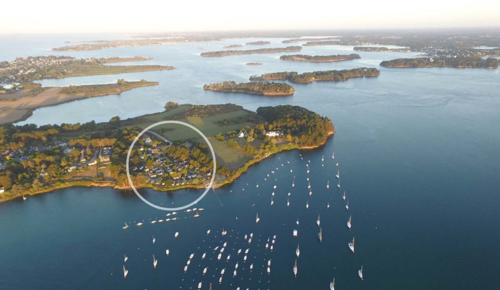
Islands in golfe du Morbihan

Legend has it that there are as many islands in the Gulf of Morbihan as there are days in the year, but there are actually less than 40, which is not bad.
Two of them stand out from the rest because of their large surface area, enabling them to accommodate permanent inhabitants: l’île aux Moines and l’île d’Arz.
The rest of the islands are privately owned, or in rarer cases owned by the state. In all cases, you have the right to dock on these islands. The French coastal law guarantees public access to any coastline. This authorization extends to 30 meters from the shore, so don’t abuse it 😉
The week of Golfe

A not-to-be-missed event in the Gulf of Morbihan, the Gulf Week takes place every two years. They bring together a large number of vintage boats, each featuring a different country.
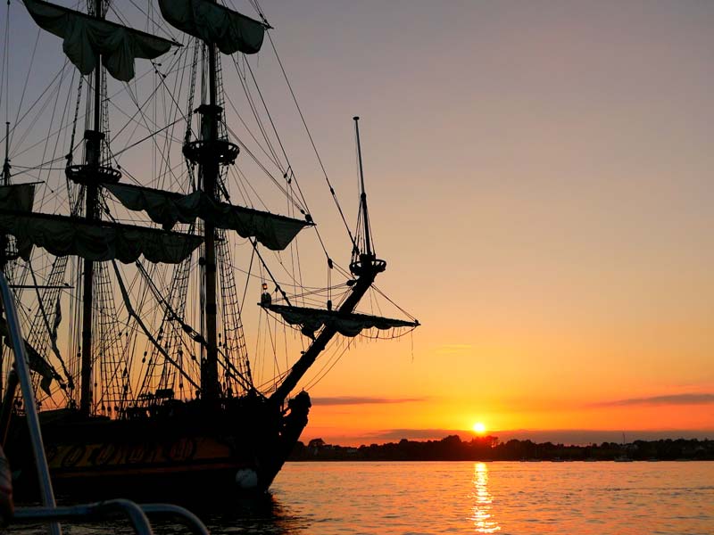
It’s a show not to be missed. All the coastal towns in the Gulf of Morbihan play their part by organizing week-long festivities.
During the day, boats divided into different fleets according to age, size or type sail between the various ports. You can see these fleets passing in front of the Bilouris campsite all week long.
The two highlights of the event are the parade in and out of the Golfe du Morbihan, where thousands of boats sail together.
Personally, my favorite part is the evening. Once all the fleets have returned to their home ports. There’s hardly anyone left on the gulf, so you have to head for the bay of Ile aux Moines, where the three-masts are anchored. Enjoy the sunset reflected on their century-old hulls, and discover that the Gulf of Morbihan, protected from real estate follies, hasn’t changed a bit in 100 years. This timeless spectacle is lulled by the sound of fest noz playing in the various ports around the gulf.